Comparaison

Photos

Callitriche obtusangula
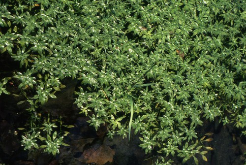
© GA
Critères
Critère
Callitriche à angles obtus
Callitriche obtusangula
Période floraison ou sporulation
  • J
  • F
  • M
  • A
  • M
  • J
  • J
  • A
  • S
  • O
  • N
  • D
Rareté Rare (R)
Hauteur mini-maxi 10 - 60 cm
Type biologique
Plante aquatique
  • Submergée
  • Flottante
Nombre de sépales
Absence de sépales
Type de fruit
Tétrakène
Dos des akènes
Aile absente
Forme des feuilles dans l'eau
Deux types de feuilles
Forme du style
Styles allongés et dressés
Longueur du pédicelle des fruits
Pédicelle inférieur à la taille du fruit
Présence de bractéoles
Présence de bractéoles de part et d'autre du fruit
Couleur dominante des pièces pétaloides
Verdâtre
Habitat
Lac, étang, rivière
Nombre de pétales ou de tépales
Aucun pétale
Nombre d'étamines
1
Port de la plante
Flottante ou submergée
Position de l'ovaire
Supère
Type de plante
Plante herbacée à fleurs
  • Plante aquatique
Disposition des feuilles
Tige aérienne avec feuilles
  • Opposées
Structure de la feuille
Feuille non découpée
  • Simple, non découpée
Forme des feuilles indivises
Rapport longueur / largeur 1-2
  • Ovale, oblongue ou obovale
Rapport longueur / largeur 2-5
  • Lancéolée
Rapport longueur / largeur > 10
  • Linéaire
Bord des limbes
Echancrures < 20% du limbe
  • Entier à marge lisse ou scabre
Type de fleur
Autre
  • Autre (Voir aide)
Dimension de la fleur en mm
Plante à fleurs nues
  • Pièces florales absentes ou transformées en soies
Type d'inflorescence
Fleur solitaire
  • Fleur solitaire
Type de fruit
Sec indéhiscent
  • Akène simple
Forme de la tige ou de la hampe florale
Tige cylindrique
  • Lisse ou finement striée
Carte des observations
[{"cd_nom": 87476, "first_year": 2023.0, "geojson_maille": {"coordinates": [[[[1.54895244544305, 49.083076853312], [1.5494553288472, 49.06509712832], [1.52209289356916, 49.0647636844845], [1.52158052838659, 49.0827432997058], [1.54895244544305, 49.083076853312]]]], "type": "MultiPolygon"}, "last_year": 2023.0, "observation_number": 1, "scientific_name": "Callitriche obtusangula"}, {"cd_nom": 87476, "first_year": 2015.0, "geojson_maille": {"coordinates": [[[[1.64189972661667, 48.6704228287694], [1.64236668781816, 48.6524360175558], [1.61521953393398, 48.6521236383065], [1.61474323919813, 48.6701103468016], [1.64189972661667, 48.6704228287694]]]], "type": "MultiPolygon"}, "last_year": 2015.0, "observation_number": 2, "scientific_name": "Callitriche obtusangula"}, {"cd_nom": 87476, "first_year": 2019.0, "geojson_maille": {"coordinates": [[[[1.7114040038975, 49.1568654658888], [1.71185122850632, 49.1388864015995], [1.68444882641294, 49.1385899530061], [1.68399209161563, 49.1565689196789], [1.7114040038975, 49.1568654658888]]]], "type": "MultiPolygon"}, "last_year": 2019.0, "observation_number": 1, "scientific_name": "Callitriche obtusangula"}, {"cd_nom": 87476, "first_year": 1994.0, "geojson_maille": {"coordinates": [[[[1.94064088192933, 48.6734518306436], [1.94100515384571, 48.6554640237063], [1.91385482200112, 48.6552196737864], [1.91348121327048, 48.6732074003698], [1.94064088192933, 48.6734518306436]]]], "type": "MultiPolygon"}, "last_year": 1994.0, "observation_number": 1, "scientific_name": "Callitriche obtusangula"}, {"cd_nom": 87476, "first_year": 1995.0, "geojson_maille": {"coordinates": [[[[1.94136917534565, 48.6374759448803], [1.94173294668727, 48.6194875959985], [1.91460126922942, 48.6192434066956], [1.91422817389919, 48.637231675284], [1.94136917534565, 48.6374759448803]]]], "type": "MultiPolygon"}, "last_year": 1995.0, "observation_number": 1, "scientific_name": "Callitriche obtusangula"}, {"cd_nom": 87476, "first_year": 1994.0, "geojson_maille": {"coordinates": [[[[1.96709019856817, 48.7096650214646], [1.96744562216761, 48.6916776854257], [1.94027635933805, 48.6914393638589], [1.93991158581302, 48.7094266215181], [1.96709019856817, 48.7096650214646]]]], "type": "MultiPolygon"}, "last_year": 1994.0, "observation_number": 1, "scientific_name": "Callitriche obtusangula"}, {"cd_nom": 87476, "first_year": 1996.0, "geojson_maille": {"coordinates": [[[[1.96815573610668, 48.6557021886025], [1.96851042695037, 48.6377140314856], [1.94136917534565, 48.6374759448803], [1.94100515384571, 48.6554640237063], [1.96815573610668, 48.6557021886025]]]], "type": "MultiPolygon"}, "last_year": 1996.0, "observation_number": 1, "scientific_name": "Callitriche obtusangula"}, {"cd_nom": 87476, "first_year": 1995.0, "geojson_maille": {"coordinates": [[[[1.96886487404561, 48.6197256043425], [1.96921907764358, 48.6017369090057], [1.94209646812832, 48.6014989788935], [1.94173294668727, 48.6194875959985], [1.96886487404561, 48.6197256043425]]]], "type": "MultiPolygon"}, "last_year": 1995.0, "observation_number": 1, "scientific_name": "Callitriche obtusangula"}, {"cd_nom": 87476, "first_year": 1994.0, "geojson_maille": {"coordinates": [[[[1.99322940491169, 48.7638577960226], [1.99357619403152, 48.74587122114], [1.96637861684678, 48.7456388596251], [1.96602245821868, 48.7636253580763], [1.99322940491169, 48.7638577960226]]]], "type": "MultiPolygon"}, "last_year": 1994.0, "observation_number": 1, "scientific_name": "Callitriche obtusangula"}, {"cd_nom": 87476, "first_year": 1996.0, "geojson_maille": {"coordinates": [[[[1.99565192230347, 48.6379459350192], [1.99599704490118, 48.6199574316469], [1.96886487404561, 48.6197256043425], [1.96851042695037, 48.6377140314856], [1.99565192230347, 48.6379459350192]]]], "type": "MultiPolygon"}, "last_year": 1996.0, "observation_number": 1, "scientific_name": "Callitriche obtusangula"}, {"cd_nom": 87476, "first_year": 1994.0, "geojson_maille": {"coordinates": [[[[1.99599704490118, 48.6199574316469], [1.99634193040524, 48.6019686601095], [1.96921907764358, 48.6017369090057], [1.96886487404561, 48.6197256043425], [1.99599704490118, 48.6199574316469]]]], "type": "MultiPolygon"}, "last_year": 1994.0, "observation_number": 1, "scientific_name": "Callitriche obtusangula"}, {"cd_nom": 87476, "first_year": 1996.0, "geojson_maille": {"coordinates": [[[[2.02077401002885, 48.746097387296], [2.02111119703121, 48.7281104570455], [1.9939227443387, 48.7278843652552], [1.99357619403152, 48.74587122114], [2.02077401002885, 48.746097387296]]]], "type": "MultiPolygon"}, "last_year": 2016.0, "observation_number": 4, "scientific_name": "Callitriche obtusangula"}, {"cd_nom": 87476, "first_year": 1996.0, "geojson_maille": {"coordinates": [[[[2.02144815191122, 48.7101232476563], [2.02178487490847, 48.6921357609633], [1.99461512950111, 48.6919098178201], [1.99426905607981, 48.7098972302036], [2.02144815191122, 48.7101232476563]]]], "type": "MultiPolygon"}, "last_year": 1996.0, "observation_number": 1, "scientific_name": "Callitriche obtusangula"}, {"cd_nom": 87476, "first_year": 1995.0, "geojson_maille": {"coordinates": [[[[2.02380035673015, 48.584205120115], [2.02413546322924, 48.5662157436297], [1.99703099110894, 48.5659903198671], [1.99668657905987, 48.5839796222391], [2.02380035673015, 48.584205120115]]]], "type": "MultiPolygon"}, "last_year": 1995.0, "observation_number": 1, "scientific_name": "Callitriche obtusangula"}, {"cd_nom": 87476, "first_year": 2012.0, "geojson_maille": {"coordinates": [[[[2.04170022163042, 49.0880149318943], [2.04203237766646, 49.0700335817113], [2.01466467593505, 49.0698123043641], [2.01432303264187, 49.0877935816939], [2.04170022163042, 49.0880149318943]]]], "type": "MultiPolygon"}, "last_year": 2012.0, "observation_number": 1, "scientific_name": "Callitriche obtusangula"}, {"cd_nom": 87476, "first_year": 1994.0, "geojson_maille": {"coordinates": [[[[2.07580703278472, 48.7105567083977], [2.07612505422272, 48.6925690791915], [2.04895485195925, 48.6923555147786], [2.04862747962532, 48.7103430737459], [2.07580703278472, 48.7105567083977]]]], "type": "MultiPolygon"}, "last_year": 1994.0, "observation_number": 1, "scientific_name": "Callitriche obtusangula"}, {"cd_nom": 87476, "first_year": 2016.0, "geojson_maille": {"coordinates": [[[[2.13136283092531, 48.6390127039343], [2.13166132749907, 48.6210238498981], [2.10452803521829, 48.6208229289283], [2.10422021299024, 48.6388117168963], [2.13136283092531, 48.6390127039343]]]], "type": "MultiPolygon"}, "last_year": 2016.0, "observation_number": 1, "scientific_name": "Callitriche obtusangula"}, {"cd_nom": 87476, "first_year": 2013.0, "geojson_maille": {"coordinates": [[[[2.17801946575048, 49.1249905842426], [2.17830457726256, 49.1070095339831], [2.15091680707653, 49.1068192936665], [2.15062219401036, 49.1248002812832], [2.17801946575048, 49.1249905842426]]]], "type": "MultiPolygon"}, "last_year": 2013.0, "observation_number": 1, "scientific_name": "Callitriche obtusangula"}, {"cd_nom": 87476, "first_year": 2024.0, "geojson_maille": {"coordinates": [[[[2.28810450118873, 49.0897265292216], [2.28835126195442, 49.0717446156862], [2.26098172536431, 49.0715794315627], [2.26072547543232, 49.0895612907108], [2.28810450118873, 49.0897265292216]]]], "type": "MultiPolygon"}, "last_year": 2024.0, "observation_number": 1, "scientific_name": "Callitriche obtusangula"}, {"cd_nom": 87476, "first_year": 2003.0, "geojson_maille": {"coordinates": [[[[2.48227542851495, 48.8389294237944], [2.48245402264551, 48.8209429624187], [2.4552156034571, 48.82082196832], [2.45502761050823, 48.838808389886], [2.48227542851495, 48.8389294237944]]]], "type": "MultiPolygon"}, "last_year": 2003.0, "observation_number": 2, "scientific_name": "Callitriche obtusangula"}, {"cd_nom": 87476, "first_year": 2023.0, "geojson_maille": {"coordinates": [[[[2.6450297313155, 48.9474390826296], [2.64515243760336, 48.9294541911744], [2.61785688224635, 48.9293702595634], [2.61772473743977, 48.9473551233944], [2.6450297313155, 48.9474390826296]]]], "type": "MultiPolygon"}, "last_year": 2023.0, "observation_number": 1, "scientific_name": "Callitriche obtusangula"}, {"cd_nom": 87476, "first_year": 2020.0, "geojson_maille": {"coordinates": [[[[2.70353564262248, 48.2639659623617], [2.70363679621991, 48.2459709529743], [2.67669497534744, 48.2459003431165], [2.676584626264, 48.2638953293071], [2.70353564262248, 48.2639659623617]]]], "type": "MultiPolygon"}, "last_year": 2020.0, "observation_number": 1, "scientific_name": "Callitriche obtusangula"}, {"cd_nom": 87476, "first_year": 2014.0, "geojson_maille": {"coordinates": [[[[2.73076241404953, 48.210044675646], [2.73085418409089, 48.1920489625764], [2.70393984327452, 48.1919845561184], [2.70383889647539, 48.209980248032], [2.73076241404953, 48.210044675646]]]], "type": "MultiPolygon"}, "last_year": 2014.0, "observation_number": 1, "scientific_name": "Callitriche obtusangula"}, {"cd_nom": 87476, "first_year": 2021.0, "geojson_maille": {"coordinates": [[[[2.75484391942374, 48.8218116458609], [2.75492846111511, 48.8038246108161], [2.72769849521607, 48.803765683391], [2.72760456021576, 48.821752699048], [2.75484391942374, 48.8218116458609]]]], "type": "MultiPolygon"}, "last_year": 2021.0, "observation_number": 1, "scientific_name": "Callitriche obtusangula"}, {"cd_nom": 87476, "first_year": 2013.0, "geojson_maille": {"coordinates": [[[[2.81088850560817, 48.390146075616], [2.81095318526544, 48.3721526497576], [2.78394662381261, 48.3721064936358], [2.78387270433404, 48.3900999043259], [2.81088850560817, 48.390146075616]]]], "type": "MultiPolygon"}, "last_year": 2013.0, "observation_number": 2, "scientific_name": "Callitriche obtusangula"}, {"cd_nom": 87476, "first_year": 2014.0, "geojson_maille": {"coordinates": [[[[2.81134033600432, 48.2641870751214], [2.81140470701516, 48.2461919931176], [2.78446264776615, 48.2461459430142], [2.78438908102513, 48.2641410098895], [2.81134033600432, 48.2641870751214]]]], "type": "MultiPolygon"}, "last_year": 2014.0, "observation_number": 1, "scientific_name": "Callitriche obtusangula"}, {"cd_nom": 87476, "first_year": 2014.0, "geojson_maille": {"coordinates": [[[[3.351686710327, 48.4617474668445], [3.35156626326345, 48.4437551490209], [3.32452302176253, 48.4438321766357], [3.3246342039935, 48.4618245197773], [3.351686710327, 48.4617474668445]]]], "type": "MultiPolygon"}, "last_year": 2014.0, "observation_number": 2, "scientific_name": "Callitriche obtusangula"}]