Comparaison

Photos

Hypericum androsaemum
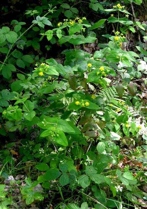
© JT
Critères
Critère
Millepertuis Androsème
Hypericum androsaemum
Période floraison ou sporulation
  • J
  • F
  • M
  • A
  • M
  • J
  • J
  • A
  • S
  • O
  • N
  • D
Rareté Extrêmement rare (RRR)
Hauteur mini-maxi 40 - 90 cm
Couleur dominante des pièces pétaloides
Jaune
Nombre de pétales ou de tépales
5
Port de la plante
Arbuste
Nombre d'étamines
>10
Habitat
Zone humide, tourbière, rives
Forêt, haie, lisière, chemin forestier (laie)
Glandes de la marge des sépales
Absence total de glandes noires
Marge des feuilles
Pas de glandes noires sur la marge des feuilles
Section tige
Cylindrique à 2 lignes saillantes
Pilosité général
Glabre
Position de l'ovaire
Supère
Etamines en fin de floraison
Regroupés en 5 faisceaux
Présence de glandes
Pas de glandes noires
Extrémité des sépales
Obtuse ou arrondie
Type de plante
Plante ligneuse
  • Arbuste
Type biologique
Plante terrestre
  • Plante ligneuse
Disposition des feuilles
Tige aérienne avec feuilles
  • Opposées
Structure de la feuille
Feuille non découpée
  • Simple, non découpée
Forme des feuilles indivises
Rapport longueur / largeur 1-2
  • Ovale, oblongue ou obovale
Bord des limbes
Echancrures < 20% du limbe
  • Entier à marge lisse ou scabre
Type de fleur
Symétrie radiale
  • Pétales ou tépales libres
Dimension de la fleur en mm
1 à 2 cm
  • 20
Type d'inflorescence
Fleurs regroupées
  • Grappe ou grappe composée
Type de fruit
Charnu
  • À plusieurs noyaux (baie, pomme, poire)
Forme de la tige ou de la hampe florale
Tige anguleuse
  • + de 4 angles
Tige cylindrique
  • Lisse ou finement striée
Carte des observations
[{"cd_nom": 103245, "first_year": 1995.0, "geojson_maille": {"coordinates": [[[[1.9939227443387, 48.7278843652552], [1.99426905607981, 48.7098972302036], [1.96709019856817, 48.7096650214646], [1.96673453021219, 48.7276520801427], [1.9939227443387, 48.7278843652552]]]], "type": "MultiPolygon"}, "last_year": 1995.0, "observation_number": 1, "scientific_name": "Hypericum androsaemum"}, {"cd_nom": 103245, "first_year": 2021.0, "geojson_maille": {"coordinates": [[[[2.01806812874438, 48.8899825599586], [2.01840718139081, 48.8719979289326], [1.99114364127536, 48.8717712414268], [1.99079517353396, 48.8897557978611], [2.01806812874438, 48.8899825599586]]]], "type": "MultiPolygon"}, "last_year": 2021.0, "observation_number": 1, "scientific_name": "Hypericum androsaemum"}, {"cd_nom": 103245, "first_year": 2017.0, "geojson_maille": {"coordinates": [[[[2.02111119703121, 48.7281104570455], [2.02144815191122, 48.7101232476563], [1.99426905607981, 48.7098972302036], [1.9939227443387, 48.7278843652552], [2.02111119703121, 48.7281104570455]]]], "type": "MultiPolygon"}, "last_year": 2017.0, "observation_number": 1, "scientific_name": "Hypericum androsaemum"}, {"cd_nom": 103245, "first_year": 2019.0, "geojson_maille": {"coordinates": [[[[2.04567095555728, 48.8722184067235], [2.04600036531265, 48.8542334093408], [2.01874599998618, 48.854013004071], [2.01840718139081, 48.8719979289326], [2.04567095555728, 48.8722184067235]]]], "type": "MultiPolygon"}, "last_year": 2019.0, "observation_number": 1, "scientific_name": "Hypericum androsaemum"}, {"cd_nom": 103245, "first_year": 2024.0, "geojson_maille": {"coordinates": [[[[2.07293495727719, 48.8724326747245], [2.07325495795703, 48.8544476068628], [2.04600036531265, 48.8542334093408], [2.04567095555728, 48.8722184067235], [2.07293495727719, 48.8724326747245]]]], "type": "MultiPolygon"}, "last_year": 2024.0, "observation_number": 1, "scientific_name": "Hypericum androsaemum"}, {"cd_nom": 103245, "first_year": 2022.0, "geojson_maille": {"coordinates": [[[[2.07802859632375, 48.5846375843944], [2.07834509101852, 48.5666480657723], [2.05124016532728, 48.5664349922895], [2.05091436461514, 48.5844244408581], [2.07802859632375, 48.5846375843944]]]], "type": "MultiPolygon"}, "last_year": 2022.0, "observation_number": 1, "scientific_name": "Hypericum androsaemum"}, {"cd_nom": 103245, "first_year": 1992.0, "geojson_maille": {"coordinates": [[[[2.10236882639109, 48.7467387128517], [2.10267792206604, 48.7287515717249], [2.07548879233908, 48.7285440603539], [2.0751703326595, 48.7465311332255], [2.10236882639109, 48.7467387128517]]]], "type": "MultiPolygon"}, "last_year": 1992.0, "observation_number": 1, "scientific_name": "Hypericum androsaemum"}, {"cd_nom": 103245, "first_year": 2008.0, "geojson_maille": {"coordinates": [[[[2.10329547526779, 48.6927764541295], [2.10360393323359, 48.6747884813299], [2.07644285687906, 48.6745811745698], [2.07612505422272, 48.6925690791915], [2.10329547526779, 48.6927764541295]]]], "type": "MultiPolygon"}, "last_year": 2008.0, "observation_number": 1, "scientific_name": "Hypericum androsaemum"}, {"cd_nom": 103245, "first_year": 2022.0, "geojson_maille": {"coordinates": [[[[2.21170795493069, 48.711532007625], [2.21197921863199, 48.6935440577552], [2.1848079867773, 48.6933614414], [2.18452737111654, 48.7113493312081], [2.21170795493069, 48.711532007625]]]], "type": "MultiPolygon"}, "last_year": 2022.0, "observation_number": 1, "scientific_name": "Hypericum androsaemum"}, {"cd_nom": 103245, "first_year": 2019.0, "geojson_maille": {"coordinates": [[[[2.29129910355313, 48.855937699807], [2.2915436550696, 48.8379518498839], [2.26429688181351, 48.8377873709121], [2.26404292607276, 48.8557731667164], [2.29129910355313, 48.855937699807]]]], "type": "MultiPolygon"}, "last_year": 2019.0, "observation_number": 2, "scientific_name": "Hypericum androsaemum"}, {"cd_nom": 103245, "first_year": 2013.0, "geojson_maille": {"coordinates": [[[[2.34240702163471, 49.1260013848466], [2.34263511973924, 49.1080200018539], [2.3152462621055, 49.1078671829823], [2.31500866131458, 49.1258485156533], [2.34240702163471, 49.1260013848466]]]], "type": "MultiPolygon"}, "last_year": 2021.0, "observation_number": 3, "scientific_name": "Hypericum androsaemum"}, {"cd_nom": 103245, "first_year": 2018.0, "geojson_maille": {"coordinates": [[[[2.37263549932609, 48.8923651720141], [2.37285213611318, 48.8743797572234], [2.34558606023103, 48.8742338012664], [2.34536000572055, 48.8922191680277], [2.37263549932609, 48.8923651720141]]]], "type": "MultiPolygon"}, "last_year": 2021.0, "observation_number": 3, "scientific_name": "Hypericum androsaemum"}, {"cd_nom": 103245, "first_year": 2013.0, "geojson_maille": {"coordinates": [[[[2.40011836155527, 48.8745195026538], [2.40032543740502, 48.8565337483567], [2.37306862334029, 48.8563940488948], [2.37285213611318, 48.8743797572234], [2.40011836155527, 48.8745195026538]]]], "type": "MultiPolygon"}, "last_year": 2018.0, "observation_number": 2, "scientific_name": "Hypericum androsaemum"}, {"cd_nom": 103245, "first_year": 2013.0, "geojson_maille": {"coordinates": [[[[3.13657503825099, 48.9658716054803], [3.13652781006043, 48.9478868673957], [3.10922228723094, 48.9479148540654], [3.10926006982406, 48.9658996013618], [3.13657503825099, 48.9658716054803]]]], "type": "MultiPolygon"}, "last_year": 2021.0, "observation_number": 6, "scientific_name": "Hypericum androsaemum"}, {"cd_nom": 103245, "first_year": 2015.0, "geojson_maille": {"coordinates": [[[[3.19041444582668, 48.7499609453961], [3.19034887198794, 48.7319727447119], [3.16315625983688, 48.7320130105748], [3.16321246607105, 48.7500012245042], [3.19041444582668, 48.7499609453961]]]], "type": "MultiPolygon"}, "last_year": 2015.0, "observation_number": 1, "scientific_name": "Hypericum androsaemum"}, {"cd_nom": 103245, "first_year": 2021.0, "geojson_maille": {"coordinates": [[[[3.19048006486036, 48.7679488655874], [3.19041444582668, 48.7499609453961], [3.16321246607105, 48.7500012245042], [3.16326871104386, 48.7679891579459], [3.19048006486036, 48.7679488655874]]]], "type": "MultiPolygon"}, "last_year": 2021.0, "observation_number": 1, "scientific_name": "Hypericum androsaemum"}, {"cd_nom": 103245, "first_year": 2011.0, "geojson_maille": {"coordinates": [[[[3.21829318368493, 48.9117952953502], [3.21821777549862, 48.8938097005554], [3.19094066748834, 48.8938562988859], [3.19100664976951, 48.911841909016], [3.21829318368493, 48.9117952953502]]]], "type": "MultiPolygon"}, "last_year": 2011.0, "observation_number": 1, "scientific_name": "Hypericum androsaemum"}, {"cd_nom": 103245, "first_year": 2016.0, "geojson_maille": {"coordinates": [[[[3.21836864400581, 48.9297805931092], [3.21829318368493, 48.9117952953502], [3.19100664976951, 48.911841909016], [3.19107267766859, 48.9298272221162], [3.21836864400581, 48.9297805931092]]]], "type": "MultiPolygon"}, "last_year": 2019.0, "observation_number": 3, "scientific_name": "Hypericum androsaemum"}, {"cd_nom": 103245, "first_year": 2014.0, "geojson_maille": {"coordinates": [[[[3.24549483142835, 48.8937568891622], [3.24541005598131, 48.8757710165445], [3.21814241939288, 48.8758238105643], [3.21821777549862, 48.8938097005554], [3.24549483142835, 48.8937568891622]]]], "type": "MultiPolygon"}, "last_year": 2020.0, "observation_number": 5, "scientific_name": "Hypericum androsaemum"}, {"cd_nom": 103245, "first_year": 2015.0, "geojson_maille": {"coordinates": [[[[3.24557966546579, 48.911742466577], [3.24549483142835, 48.8937568891622], [3.21821777549862, 48.8938097005554], [3.21829318368493, 48.9117952953502], [3.24557966546579, 48.911742466577]]]], "type": "MultiPolygon"}, "last_year": 2015.0, "observation_number": 1, "scientific_name": "Hypericum androsaemum"}, {"cd_nom": 103245, "first_year": 2014.0, "geojson_maille": {"coordinates": [[[[3.27277182876769, 48.8936978647244], [3.27267763404003, 48.875712011524], [3.24541005598131, 48.8757710165445], [3.24549483142835, 48.8937568891622], [3.27277182876769, 48.8936978647244]]]], "type": "MultiPolygon"}, "last_year": 2016.0, "observation_number": 2, "scientific_name": "Hypericum androsaemum"}, {"cd_nom": 103245, "first_year": 2015.0, "geojson_maille": {"coordinates": [[[[3.35509305986481, 48.9654236733276], [3.3549702686845, 48.9474390826296], [3.32766518991633, 48.9475168227771], [3.3277785359602, 48.965501439063], [3.35509305986481, 48.9654236733276]]]], "type": "MultiPolygon"}, "last_year": 2015.0, "observation_number": 1, "scientific_name": "Hypericum androsaemum"}]