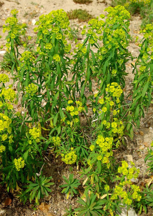
Comparaison

Photos

Euphorbia esula

© GA
Critères
Critère
Euphorbe ésule
Euphorbia esula
Période floraison ou sporulation
  • J
  • F
  • M
  • A
  • M
  • J
  • J
  • A
  • S
  • O
  • N
  • D
Rareté Très rare (RR)
Hauteur mini-maxi 50 - 80 cm
Couleur dominante des pièces pétaloides
Pas de calice ni de corolle
Nombre de pétales ou de tépales
Aucun pétale
4
Caractère particulier
Tige contenant un suc laiteux
Habitat
Mégaphorbiaie
Terrain vague, chemin
Nombre d'étamines
1
Port de la plante
Tige dressée
Position de l'ovaire
Supère
Nombre de graines par loge
1 graine par carpelle ( 2 ou 3 au total par fruit)
Détail du fruit
Capsule à 3 loges (tricoque)
Caractère particulier
Présence de latex
Dimension du fruit
Capsule de 2 à 3 mm
Capsule de 3 à 5 mm
Forme des bractéoles sous-tendant les fleurs du so
Semi-circulaires ou largement ovales libres
Forme des glandes nectarifères
En forme de croissant ou de cornes
Nombre de rayons principaux de l'ombelle
6 à 9 rayons
Plus de 9 rayons
Ornementation des graines
Lisses
Ornementation du fruit
Finement granuleux sur tout le dos des loges
Pilosité de la plante
Parfaitement glabre
Pilosite des capsules
Capsules entièrement glabres parfois verruqueuses
Type de plante
Plante herbacée à fleurs
  • Autre plante herbacée à fleur
Type biologique
Plante terrestre
  • Plante vivace en surface
  • Plante vivace souterraine
Disposition des feuilles
Tige aérienne avec feuilles
  • Alternes
Structure de la feuille
Feuille non découpée
  • Simple, non découpée
Forme des feuilles indivises
Rapport longueur / largeur 2-5
  • Lancéolée
  • Ovale lancéolée ou oblancéolée
Rapport longueur / largeur > 10
  • Linéaire
Bord des limbes
Echancrures < 20% du limbe
  • Entier à marge ondulée
Type de fleur
Symétrie radiale
  • Pétales ou tépales libres
Autre
  • Autre (Voir aide)
Dimension de la fleur en mm
Moins de 5 mm
  • 2
Type d'inflorescence
Fleurs regroupées
  • Cyathe
Type de fruit
Sec déhiscent
  • À autre mode d'ouverture (capsule)
Forme de la tige ou de la hampe florale
Tige cylindrique
  • Lisse ou finement striée
Carte des observations
[{"cd_nom": 97508, "first_year": 2024.0, "geojson_maille": {"coordinates": [[[[1.57632471126624, 49.0834041742515], [1.57681811252957, 49.0654243415391], [1.5494553288472, 49.06509712832], [1.54895244544305, 49.083076853312], [1.57632471126624, 49.0834041742515]]]], "type": "MultiPolygon"}, "last_year": 2024.0, "observation_number": 1, "scientific_name": "Euphorbia esula"}, {"cd_nom": 97508, "first_year": 2018.0, "geojson_maille": {"coordinates": [[[[2.17716294288582, 49.1789318107812], [2.1774486487684, 49.160951724488], [2.15003235413055, 49.1607612961714], [2.14973712689057, 49.17874131975], [2.17716294288582, 49.1789318107812]]]], "type": "MultiPolygon"}, "last_year": 2018.0, "observation_number": 1, "scientific_name": "Euphorbia esula"}, {"cd_nom": 97508, "first_year": 2020.0, "geojson_maille": {"coordinates": [[[[2.40011836155527, 48.8745195026538], [2.40032543740502, 48.8565337483567], [2.37306862334029, 48.8563940488948], [2.37285213611318, 48.8743797572234], [2.40011836155527, 48.8745195026538]]]], "type": "MultiPolygon"}, "last_year": 2020.0, "observation_number": 1, "scientific_name": "Euphorbia esula"}, {"cd_nom": 97508, "first_year": 2010.0, "geojson_maille": {"coordinates": [[[[2.75644030240809, 48.4800108493874], [2.75652374685471, 48.462018693649], [2.72947103094771, 48.4619601332025], [2.72937831510275, 48.4799522696917], [2.75644030240809, 48.4800108493874]]]], "type": "MultiPolygon"}, "last_year": 2010.0, "observation_number": 1, "scientific_name": "Euphorbia esula"}, {"cd_nom": 97508, "first_year": 2010.0, "geojson_maille": {"coordinates": [[[[2.75652374685471, 48.462018693649], [2.75660713414435, 48.4440262867055], [2.72956368328519, 48.4439677455008], [2.72947103094771, 48.4619601332025], [2.75652374685471, 48.462018693649]]]], "type": "MultiPolygon"}, "last_year": 2010.0, "observation_number": 1, "scientific_name": "Euphorbia esula"}, {"cd_nom": 97508, "first_year": 2010.0, "geojson_maille": {"coordinates": [[[[2.75660713414435, 48.4440262867055], [2.75669046433571, 48.4260336303837], [2.72965627218043, 48.4259751084137], [2.72956368328519, 48.4439677455008], [2.75660713414435, 48.4440262867055]]]], "type": "MultiPolygon"}, "last_year": 2010.0, "observation_number": 1, "scientific_name": "Euphorbia esula"}, {"cd_nom": 97508, "first_year": 2010.0, "geojson_maille": {"coordinates": [[[[2.75669046433571, 48.4260336303837], [2.75677373748742, 48.4080407265102], [2.72974879769855, 48.4079822237676], [2.72965627218043, 48.4259751084137], [2.75669046433571, 48.4260336303837]]]], "type": "MultiPolygon"}, "last_year": 2010.0, "observation_number": 1, "scientific_name": "Euphorbia esula"}, {"cd_nom": 97508, "first_year": 2010.0, "geojson_maille": {"coordinates": [[[[2.75677373748742, 48.4080407265102], [2.75685695365801, 48.3900475769109], [2.72984125990462, 48.3899890933886], [2.72974879769855, 48.4079822237676], [2.75677373748742, 48.4080407265102]]]], "type": "MultiPolygon"}, "last_year": 2010.0, "observation_number": 1, "scientific_name": "Euphorbia esula"}, {"cd_nom": 97508, "first_year": 2010.0, "geojson_maille": {"coordinates": [[[[2.75685695365801, 48.3900475769109], [2.75694011290597, 48.3720541834114], [2.72993365886358, 48.3719957191021], [2.72984125990462, 48.3899890933886], [2.75685695365801, 48.3900475769109]]]], "type": "MultiPolygon"}, "last_year": 2010.0, "observation_number": 1, "scientific_name": "Euphorbia esula"}, {"cd_nom": 97508, "first_year": 2010.0, "geojson_maille": {"coordinates": [[[[2.75785112438044, 48.1741112790875], [2.75793360508802, 48.15611510099], [2.73103753662244, 48.156056866676], [2.73094589159389, 48.1740530256466], [2.75785112438044, 48.1741112790875]]]], "type": "MultiPolygon"}, "last_year": 2010.0, "observation_number": 1, "scientific_name": "Euphorbia esula"}, {"cd_nom": 97508, "first_year": 2010.0, "geojson_maille": {"coordinates": [[[[2.78350234692918, 48.4800632628525], [2.78357651991868, 48.4620710898912], [2.75652374685471, 48.462018693649], [2.75644030240809, 48.4800108493874], [2.78350234692918, 48.4800632628525]]]], "type": "MultiPolygon"}, "last_year": 2010.0, "observation_number": 1, "scientific_name": "Euphorbia esula"}, {"cd_nom": 97508, "first_year": 2010.0, "geojson_maille": {"coordinates": [[[[2.78357651991868, 48.4620710898912], [2.78365064210177, 48.4440786657311], [2.75660713414435, 48.4440262867055], [2.75652374685471, 48.462018693649], [2.78357651991868, 48.4620710898912]]]], "type": "MultiPolygon"}, "last_year": 2010.0, "observation_number": 1, "scientific_name": "Euphorbia esula"}, {"cd_nom": 97508, "first_year": 2010.0, "geojson_maille": {"coordinates": [[[[2.78365064210177, 48.4440786657311], [2.78372471353063, 48.4260859921993], [2.75669046433571, 48.4260336303837], [2.75660713414435, 48.4440262867055], [2.78365064210177, 48.4440786657311]]]], "type": "MultiPolygon"}, "last_year": 2010.0, "observation_number": 1, "scientific_name": "Euphorbia esula"}, {"cd_nom": 97508, "first_year": 2010.0, "geojson_maille": {"coordinates": [[[[2.78372471353063, 48.4260859921993], [2.78379873425737, 48.4080930711222], [2.75677373748742, 48.4080407265102], [2.75669046433571, 48.4260336303837], [2.78372471353063, 48.4260859921993]]]], "type": "MultiPolygon"}, "last_year": 2010.0, "observation_number": 1, "scientific_name": "Euphorbia esula"}, {"cd_nom": 97508, "first_year": 2010.0, "geojson_maille": {"coordinates": [[[[2.78379873425737, 48.4080930711222], [2.78387270433404, 48.3900999043259], [2.75685695365801, 48.3900475769109], [2.75677373748742, 48.4080407265102], [2.78379873425737, 48.4080930711222]]]], "type": "MultiPolygon"}, "last_year": 2010.0, "observation_number": 1, "scientific_name": "Euphorbia esula"}, {"cd_nom": 97508, "first_year": 2010.0, "geojson_maille": {"coordinates": [[[[2.78387270433404, 48.3900999043259], [2.78394662381261, 48.3721064936358], [2.75694011290597, 48.3720541834114], [2.75685695365801, 48.3900475769109], [2.78387270433404, 48.3900999043259]]]], "type": "MultiPolygon"}, "last_year": 2010.0, "observation_number": 1, "scientific_name": "Euphorbia esula"}, {"cd_nom": 97508, "first_year": 2024.0, "geojson_maille": {"coordinates": [[[[2.78402049274497, 48.3541128408769], [2.78409431118294, 48.3361189478737], [2.75710626086742, 48.3360666720112], [2.75702321528967, 48.3540605478367], [2.78402049274497, 48.3541128408769]]]], "type": "MultiPolygon"}, "last_year": 2024.0, "observation_number": 1, "scientific_name": "Euphorbia esula"}, {"cd_nom": 97508, "first_year": 2010.0, "geojson_maille": {"coordinates": [[[[2.81056444230893, 48.4801095100692], [2.81062934378905, 48.4621173219111], [2.78357651991868, 48.4620710898912], [2.78350234692918, 48.4800632628525], [2.81056444230893, 48.4801095100692]]]], "type": "MultiPolygon"}, "last_year": 2010.0, "observation_number": 1, "scientific_name": "Euphorbia esula"}, {"cd_nom": 97508, "first_year": 2010.0, "geojson_maille": {"coordinates": [[[[2.81062934378905, 48.4621173219111], [2.8106942008134, 48.44412488256], [2.78365064210177, 48.4440786657311], [2.78357651991868, 48.4620710898912], [2.81062934378905, 48.4621173219111]]]], "type": "MultiPolygon"}, "last_year": 2010.0, "observation_number": 1, "scientific_name": "Euphorbia esula"}, {"cd_nom": 97508, "first_year": 2010.0, "geojson_maille": {"coordinates": [[[[2.8106942008134, 48.44412488256], [2.81075901342765, 48.4261321938429], [2.78372471353063, 48.4260859921993], [2.78365064210177, 48.4440786657311], [2.8106942008134, 48.44412488256]]]], "type": "MultiPolygon"}, "last_year": 2010.0, "observation_number": 1, "scientific_name": "Euphorbia esula"}, {"cd_nom": 97508, "first_year": 2010.0, "geojson_maille": {"coordinates": [[[[2.81075901342765, 48.4261321938429], [2.81082378167739, 48.4081392575862], [2.78379873425737, 48.4080930711222], [2.78372471353063, 48.4260859921993], [2.81075901342765, 48.4261321938429]]]], "type": "MultiPolygon"}, "last_year": 2010.0, "observation_number": 1, "scientific_name": "Euphorbia esula"}, {"cd_nom": 97508, "first_year": 2010.0, "geojson_maille": {"coordinates": [[[[2.81082378167739, 48.4081392575862], [2.81088850560817, 48.390146075616], [2.78387270433404, 48.3900999043259], [2.78379873425737, 48.4080930711222], [2.81082378167739, 48.4081392575862]]]], "type": "MultiPolygon"}, "last_year": 2010.0, "observation_number": 1, "scientific_name": "Euphorbia esula"}, {"cd_nom": 97508, "first_year": 2010.0, "geojson_maille": {"coordinates": [[[[2.81088850560817, 48.390146075616], [2.81095318526544, 48.3721526497576], [2.78394662381261, 48.3721064936358], [2.78387270433404, 48.3900999043259], [2.81088850560817, 48.390146075616]]]], "type": "MultiPolygon"}, "last_year": 2010.0, "observation_number": 1, "scientific_name": "Euphorbia esula"}, {"cd_nom": 97508, "first_year": 2010.0, "geojson_maille": {"coordinates": [[[[2.83762658219015, 48.480149591022], [2.83768221211517, 48.4621573896934], [2.81062934378905, 48.4621173219111], [2.81056444230893, 48.4801095100692], [2.83762658219015, 48.480149591022]]]], "type": "MultiPolygon"}, "last_year": 2010.0, "observation_number": 1, "scientific_name": "Euphorbia esula"}, {"cd_nom": 97508, "first_year": 2010.0, "geojson_maille": {"coordinates": [[[[2.83768221211517, 48.4621573896934], [2.83773780393513, 48.4441649371767], [2.8106942008134, 48.44412488256], [2.81062934378905, 48.4621173219111], [2.83768221211517, 48.4621573896934]]]], "type": "MultiPolygon"}, "last_year": 2010.0, "observation_number": 1, "scientific_name": "Euphorbia esula"}, {"cd_nom": 97508, "first_year": 2010.0, "geojson_maille": {"coordinates": [[[[2.83773780393513, 48.4441649371767], [2.83779335768917, 48.4261722352989], [2.81075901342765, 48.4261321938429], [2.8106942008134, 48.44412488256], [2.83773780393513, 48.4441649371767]]]], "type": "MultiPolygon"}, "last_year": 2010.0, "observation_number": 1, "scientific_name": "Euphorbia esula"}, {"cd_nom": 97508, "first_year": 2010.0, "geojson_maille": {"coordinates": [[[[2.83779335768917, 48.4261722352989], [2.83784887341638, 48.4081792858865], [2.81082378167739, 48.4081392575862], [2.81075901342765, 48.4261321938429], [2.83779335768917, 48.4261722352989]]]], "type": "MultiPolygon"}, "last_year": 2010.0, "observation_number": 1, "scientific_name": "Euphorbia esula"}, {"cd_nom": 97508, "first_year": 2010.0, "geojson_maille": {"coordinates": [[[[2.83784887341638, 48.4081792858865], [2.83790435115578, 48.3901860907655], [2.81088850560817, 48.390146075616], [2.81082378167739, 48.4081392575862], [2.83784887341638, 48.4081792858865]]]], "type": "MultiPolygon"}, "last_year": 2010.0, "observation_number": 1, "scientific_name": "Euphorbia esula"}, {"cd_nom": 97508, "first_year": 2010.0, "geojson_maille": {"coordinates": [[[[2.83790435115578, 48.3901860907655], [2.83795979094634, 48.3721926517613], [2.81095318526544, 48.3721526497576], [2.81088850560817, 48.390146075616], [2.83790435115578, 48.3901860907655]]]], "type": "MultiPolygon"}, "last_year": 2010.0, "observation_number": 1, "scientific_name": "Euphorbia esula"}, {"cd_nom": 97508, "first_year": 2010.0, "geojson_maille": {"coordinates": [[[[2.86468876021562, 48.4801835056973], [2.86473511854635, 48.4621912932243], [2.83768221211517, 48.4621573896934], [2.83762658219015, 48.480149591022], [2.86468876021562, 48.4801835056973]]]], "type": "MultiPolygon"}, "last_year": 2010.0, "observation_number": 1, "scientific_name": "Euphorbia esula"}, {"cd_nom": 97508, "first_year": 2010.0, "geojson_maille": {"coordinates": [[[[2.86473511854635, 48.4621912932243], [2.86478144512278, 48.4441988295675], [2.83773780393513, 48.4441649371767], [2.83768221211517, 48.4621573896934], [2.86473511854635, 48.4621912932243]]]], "type": "MultiPolygon"}, "last_year": 2010.0, "observation_number": 1, "scientific_name": "Euphorbia esula"}, {"cd_nom": 97508, "first_year": 2010.0, "geojson_maille": {"coordinates": [[[[2.86478144512278, 48.4441988295675], [2.86482773997752, 48.4262061165538], [2.83779335768917, 48.4261722352989], [2.83773780393513, 48.4441649371767], [2.86478144512278, 48.4441988295675]]]], "type": "MultiPolygon"}, "last_year": 2010.0, "observation_number": 1, "scientific_name": "Euphorbia esula"}, {"cd_nom": 97508, "first_year": 2010.0, "geojson_maille": {"coordinates": [[[[2.86482773997752, 48.4262061165538], [2.86487400314316, 48.4082131560096], [2.83784887341638, 48.4081792858865], [2.83779335768917, 48.4261722352989], [2.86482773997752, 48.4262061165538]]]], "type": "MultiPolygon"}, "last_year": 2010.0, "observation_number": 1, "scientific_name": "Euphorbia esula"}, {"cd_nom": 97508, "first_year": 2010.0, "geojson_maille": {"coordinates": [[[[2.86487400314316, 48.4082131560096], [2.8649202346522, 48.390219949761], [2.83790435115578, 48.3901860907655], [2.83784887341638, 48.4081792858865], [2.86487400314316, 48.4082131560096]]]], "type": "MultiPolygon"}, "last_year": 2010.0, "observation_number": 1, "scientific_name": "Euphorbia esula"}, {"cd_nom": 97508, "first_year": 2010.0, "geojson_maille": {"coordinates": [[[[2.8649202346522, 48.390219949761], [2.86496643453715, 48.3722264996335], [2.83795979094634, 48.3721926517613], [2.83790435115578, 48.3901860907655], [2.8649202346522, 48.390219949761]]]], "type": "MultiPolygon"}, "last_year": 2010.0, "observation_number": 1, "scientific_name": "Euphorbia esula"}, {"cd_nom": 97508, "first_year": 2021.0, "geojson_maille": {"coordinates": [[[[3.02723025734073, 48.8040727269868], [3.02722087020662, 48.7860853243264], [3, 48.7860884247656], [3, 48.8040758284461], [3.02723025734073, 48.8040727269868]]]], "type": "MultiPolygon"}, "last_year": 2021.0, "observation_number": 1, "scientific_name": "Euphorbia esula"}, {"cd_nom": 97508, "first_year": 2015.0, "geojson_maille": {"coordinates": [[[[3.27043631671481, 48.4439677455008], [3.27034372781957, 48.4259751084137], [3.24330953566429, 48.4260336303837], [3.24339286585565, 48.4440262867055], [3.27043631671481, 48.4439677455008]]]], "type": "MultiPolygon"}, "last_year": 2015.0, "observation_number": 1, "scientific_name": "Euphorbia esula"}, {"cd_nom": 97508, "first_year": 2014.0, "geojson_maille": {"coordinates": [[[[3.29747970413173, 48.4439030421369], [3.29737785659776, 48.4259104263091], [3.27034372781957, 48.4259751084137], [3.27043631671481, 48.4439677455008], [3.29747970413173, 48.4439030421369]]]], "type": "MultiPolygon"}, "last_year": 2014.0, "observation_number": 1, "scientific_name": "Euphorbia esula"}, {"cd_nom": 97508, "first_year": 2024.0, "geojson_maille": {"coordinates": [[[[3.3246342039935, 48.4618245197773], [3.32452302176253, 48.4438321766357], [3.29747970413173, 48.4439030421369], [3.29758162145182, 48.4618954085713], [3.3246342039935, 48.4618245197773]]]], "type": "MultiPolygon"}, "last_year": 2024.0, "observation_number": 1, "scientific_name": "Euphorbia esula"}]