[{"cd_nom": 113809, "first_year": 2020.0, "geojson_maille": {"coordinates": [[[[1.38192173169275, 49.1708724349522], [1.38248344507269, 49.1528950017822], [1.35507577500421, 49.1525235658975], [1.3545045492544, 49.1705008767631], [1.38192173169275, 49.1708724349522]]]], "type": "MultiPolygon"}, "last_year": 2020.0, "observation_number": 1, "scientific_name": "Plantago arenaria"}, {"cd_nom": 113809, "first_year": 2016.0, "geojson_maille": {"coordinates": [[[[1.63249258490824, 49.0300990498228], [1.6329660357305, 49.0121180696541], [1.60563098410168, 49.0118036286229], [1.60514807011189, 49.0297845052907], [1.63249258490824, 49.0300990498228]]]], "type": "MultiPolygon"}, "last_year": 2017.0, "observation_number": 2, "scientific_name": "Plantago arenaria"}, {"cd_nom": 113809, "first_year": 2017.0, "geojson_maille": {"coordinates": [[[[1.6584435356151, 49.0843487399597], [1.65890848834979, 49.0663685963889], [1.63154469884665, 49.0660600756823], [1.63107026292486, 49.0840401176842], [1.6584435356151, 49.0843487399597]]]], "type": "MultiPolygon"}, "last_year": 2020.0, "observation_number": 2, "scientific_name": "Plantago arenaria"}, {"cd_nom": 113809, "first_year": 2017.0, "geojson_maille": {"coordinates": [[[[1.65890848834979, 49.0663685963889], [1.65937311894317, 49.0483881382901], [1.63201880606062, 49.0480797191136], [1.63154469884665, 49.0660600756823], [1.65890848834979, 49.0663685963889]]]], "type": "MultiPolygon"}, "last_year": 2017.0, "observation_number": 1, "scientific_name": "Plantago arenaria"}, {"cd_nom": 113809, "first_year": 2019.0, "geojson_maille": {"coordinates": [[[[1.65937311894317, 49.0483881382901], [1.65983742772987, 49.0304073675079], [1.63249258490824, 49.0300990498228], [1.63201880606062, 49.0480797191136], [1.65937311894317, 49.0483881382901]]]], "type": "MultiPolygon"}, "last_year": 2021.0, "observation_number": 2, "scientific_name": "Plantago arenaria"}, {"cd_nom": 113809, "first_year": 2019.0, "geojson_maille": {"coordinates": [[[[1.8048451738331, 48.6721678103925], [1.80525612710374, 48.6541804255591], [1.77810714357564, 48.6539051518059], [1.77768685488237, 48.6718924461186], [1.8048451738331, 48.6721678103925]]]], "type": "MultiPolygon"}, "last_year": 2019.0, "observation_number": 1, "scientific_name": "Plantago arenaria"}, {"cd_nom": 113809, "first_year": 2016.0, "geojson_maille": {"coordinates": [[[[1.87938345963393, 48.9966857825784], [1.87977119021128, 48.9787033474948], [1.85245233744885, 48.9784451032984], [1.85205515397631, 48.9964274533827], [1.87938345963393, 48.9966857825784]]]], "type": "MultiPolygon"}, "last_year": 2016.0, "observation_number": 1, "scientific_name": "Plantago arenaria"}, {"cd_nom": 113809, "first_year": 2016.0, "geojson_maille": {"coordinates": [[[[1.87977119021128, 48.9787033474948], [1.88015865259176, 48.960720607382], [1.8528492461886, 48.9604624481525], [1.85245233744885, 48.9784451032984], [1.87977119021128, 48.9787033474948]]]], "type": "MultiPolygon"}, "last_year": 2020.0, "observation_number": 2, "scientific_name": "Plantago arenaria"}, {"cd_nom": 113809, "first_year": 2018.0, "geojson_maille": {"coordinates": [[[[1.9067120337669, 48.9969378881518], [1.90709031117052, 48.9789553701161], [1.87977119021128, 48.9787033474948], [1.87938345963393, 48.9966857825784], [1.9067120337669, 48.9969378881518]]]], "type": "MultiPolygon"}, "last_year": 2018.0, "observation_number": 1, "scientific_name": "Plantago arenaria"}, {"cd_nom": 113809, "first_year": 2011.0, "geojson_maille": {"coordinates": [[[[2.01670957279114, 48.9619181089129], [2.0170495640711, 48.9439346716274], [1.98974832452502, 48.9437076855848], [1.98939889209376, 48.961691048165], [2.01670957279114, 48.9619181089129]]]], "type": "MultiPolygon"}, "last_year": 2011.0, "observation_number": 2, "scientific_name": "Plantago arenaria"}, {"cd_nom": 113809, "first_year": 2021.0, "geojson_maille": {"coordinates": [[[[2.16282244765196, 48.3693464282677], [2.1631086597434, 48.3513536821776], [2.13611428539661, 48.351159900336], [2.13581884283335, 48.3691525827507], [2.16282244765196, 48.3693464282677]]]], "type": "MultiPolygon"}, "last_year": 2021.0, "observation_number": 1, "scientific_name": "Plantago arenaria"}, {"cd_nom": 113809, "first_year": 2019.0, "geojson_maille": {"coordinates": [[[[2.18788206113623, 48.4954768857662], [2.18816037322857, 48.4774858130716], [2.16110105572285, 48.4772977503139], [2.16081346862182, 48.4952887611918], [2.18788206113623, 48.4954768857662]]]], "type": "MultiPolygon"}, "last_year": 2022.0, "observation_number": 2, "scientific_name": "Plantago arenaria"}, {"cd_nom": 113809, "first_year": 1995.0, "geojson_maille": {"coordinates": [[[[2.2915436550696, 48.8379518498839], [2.29178803787397, 48.8199657100428], [2.26455066235544, 48.8198012851691], [2.26429688181351, 48.8377873709121], [2.2915436550696, 48.8379518498839]]]], "type": "MultiPolygon"}, "last_year": 1995.0, "observation_number": 1, "scientific_name": "Plantago arenaria"}, {"cd_nom": 113809, "first_year": 2014.0, "geojson_maille": {"coordinates": [[[[2.32438584337658, 48.4063657253433], [2.32461698468219, 48.3883731260317], [2.29760306173521, 48.3882161488868], [2.29736267621285, 48.4062086966108], [2.32438584337658, 48.4063657253433]]]], "type": "MultiPolygon"}, "last_year": 2024.0, "observation_number": 7, "scientific_name": "Plantago arenaria"}, {"cd_nom": 113809, "first_year": 2023.0, "geojson_maille": {"coordinates": [[[[2.37241871282399, 48.9103502914278], [2.37263549932609, 48.8923651720141], [2.34536000572055, 48.8922191680277], [2.34513379498745, 48.9102042393937], [2.37241871282399, 48.9103502914278]]]], "type": "MultiPolygon"}, "last_year": 2023.0, "observation_number": 1, "scientific_name": "Plantago arenaria"}, {"cd_nom": 113809, "first_year": 2018.0, "geojson_maille": {"coordinates": [[[[2.40053237034395, 48.8385477023779], [2.40073916051995, 48.8205613665553], [2.37350114973363, 48.8204217589779], [2.37328496116223, 48.838408048867], [2.40053237034395, 48.8385477023779]]]], "type": "MultiPolygon"}, "last_year": 2018.0, "observation_number": 1, "scientific_name": "Plantago arenaria"}, {"cd_nom": 113809, "first_year": 2015.0, "geojson_maille": {"coordinates": [[[[2.40565967682383, 48.3888071240095], [2.40586294539983, 48.3708141380184], [2.37885780548657, 48.3706756731539], [2.3786452985488, 48.3886686136428], [2.40565967682383, 48.3888071240095]]]], "type": "MultiPolygon"}, "last_year": 2020.0, "observation_number": 3, "scientific_name": "Plantago arenaria"}, {"cd_nom": 113809, "first_year": 2019.0, "geojson_maille": {"coordinates": [[[[2.40606607498742, 48.3528209097991], [2.4062690657291, 48.3348274411762], [2.37928238359749, 48.3346890672649], [2.37907016711981, 48.3526824904197], [2.40606607498742, 48.3528209097991]]]], "type": "MultiPolygon"}, "last_year": 2023.0, "observation_number": 2, "scientific_name": "Plantago arenaria"}, {"cd_nom": 113809, "first_year": 2023.0, "geojson_maille": {"coordinates": [[[[2.4062690657291, 48.3348274411762], [2.40647191776718, 48.3168337339739], [2.37949445506837, 48.3166954055135], [2.37928238359749, 48.3346890672649], [2.4062690657291, 48.3348274411762]]]], "type": "MultiPolygon"}, "last_year": 2024.0, "observation_number": 2, "scientific_name": "Plantago arenaria"}, {"cd_nom": 113809, "first_year": 2023.0, "geojson_maille": {"coordinates": [[[[2.42758239438053, 48.8566672392872], [2.42777992228856, 48.8386811493994], [2.40053237034395, 48.8385477023779], [2.40032543740502, 48.8565337483567], [2.42758239438053, 48.8566672392872]]]], "type": "MultiPolygon"}, "last_year": 2023.0, "observation_number": 2, "scientific_name": "Plantago arenaria"}, {"cd_nom": 113809, "first_year": 2018.0, "geojson_maille": {"coordinates": [[[[2.43248003135011, 48.4069322641213], [2.43267419422994, 48.3889394786871], [2.40565967682383, 48.3888071240095], [2.40545626911672, 48.4067998659473], [2.43248003135011, 48.4069322641213]]]], "type": "MultiPolygon"}, "last_year": 2020.0, "observation_number": 4, "scientific_name": "Plantago arenaria"}, {"cd_nom": 113809, "first_year": 2019.0, "geojson_maille": {"coordinates": [[[[2.43306212170091, 48.3529531775329], [2.43325588656429, 48.3349596654626], [2.4062690657291, 48.3348274411762], [2.40606607498742, 48.3528209097991], [2.43306212170091, 48.3529531775329]]]], "type": "MultiPolygon"}, "last_year": 2024.0, "observation_number": 4, "scientific_name": "Plantago arenaria"}, {"cd_nom": 113809, "first_year": 2023.0, "geojson_maille": {"coordinates": [[[[2.43325588656429, 48.3349596654626], [2.43344951902744, 48.316965914829], [2.40647191776718, 48.3168337339739], [2.4062690657291, 48.3348274411762], [2.43325588656429, 48.3349596654626]]]], "type": "MultiPolygon"}, "last_year": 2024.0, "observation_number": 2, "scientific_name": "Plantago arenaria"}, {"cd_nom": 113809, "first_year": 1998.0, "geojson_maille": {"coordinates": [[[[2.45389692257419, 48.9467207688973], [2.45408569626596, 48.9287361137793], [2.42679091717115, 48.9286086637989], [2.4265927057662, 48.9465932769704], [2.45389692257419, 48.9467207688973]]]], "type": "MultiPolygon"}, "last_year": 1998.0, "observation_number": 1, "scientific_name": "Plantago arenaria"}, {"cd_nom": 113809, "first_year": 2023.0, "geojson_maille": {"coordinates": [[[[2.46005830095044, 48.3530792935766], [2.46024283979967, 48.3350857400794], [2.43325588656429, 48.3349596654626], [2.43306212170091, 48.3529531775329], [2.46005830095044, 48.3530792935766]]]], "type": "MultiPolygon"}, "last_year": 2023.0, "observation_number": 1, "scientific_name": "Plantago arenaria"}, {"cd_nom": 113809, "first_year": 2023.0, "geojson_maille": {"coordinates": [[[[2.46024283979967, 48.3350857400794], [2.46042725255224, 48.3170919480345], [2.43344951902744, 48.316965914829], [2.43325588656429, 48.3349596654626], [2.46024283979967, 48.3350857400794]]]], "type": "MultiPolygon"}, "last_year": 2024.0, "observation_number": 2, "scientific_name": "Plantago arenaria"}, {"cd_nom": 113809, "first_year": 2016.0, "geojson_maille": {"coordinates": [[[[2.56760071009486, 48.407501887824], [2.56774864692219, 48.3895089152514], [2.54073352870634, 48.3894073396466], [2.54057634643467, 48.4074002788374], [2.56760071009486, 48.407501887824]]]], "type": "MultiPolygon"}, "last_year": 2018.0, "observation_number": 2, "scientific_name": "Plantago arenaria"}, {"cd_nom": 113809, "first_year": 2014.0, "geojson_maille": {"coordinates": [[[[2.59462517505062, 48.407597338862], [2.59476386632968, 48.3896043349307], [2.56774864692219, 48.3895089152514], [2.56760071009486, 48.407501887824], [2.59462517505062, 48.407597338862]]]], "type": "MultiPolygon"}, "last_year": 2021.0, "observation_number": 11, "scientific_name": "Plantago arenaria"}, {"cd_nom": 113809, "first_year": 2016.0, "geojson_maille": {"coordinates": [[[[2.62255399815653, 48.2817303400859], [2.62268282588508, 48.2637356375193], [2.59573205442242, 48.2636465788399], [2.59559402517973, 48.2816412521477], [2.62255399815653, 48.2817303400859]]]], "type": "MultiPolygon"}, "last_year": 2016.0, "observation_number": 1, "scientific_name": "Plantago arenaria"}, {"cd_nom": 113809, "first_year": 2014.0, "geojson_maille": {"coordinates": [[[[2.64867438352758, 48.4077697669652], [2.64879458342429, 48.3897767063856], [2.62177918060502, 48.3896935986521], [2.62164973497166, 48.4076866319191], [2.64867438352758, 48.4077697669652]]]], "type": "MultiPolygon"}, "last_year": 2024.0, "observation_number": 2, "scientific_name": "Plantago arenaria"}, {"cd_nom": 113809, "first_year": 2021.0, "geojson_maille": {"coordinates": [[[[2.67569911438782, 48.4078467439723], [2.67581006846343, 48.3898536581031], [2.64879458342429, 48.3897767063856], [2.64867438352758, 48.4077697669652], [2.67569911438782, 48.4078467439723]]]], "type": "MultiPolygon"}, "last_year": 2024.0, "observation_number": 3, "scientific_name": "Plantago arenaria"}, {"cd_nom": 113809, "first_year": 2014.0, "geojson_maille": {"coordinates": [[[[2.67581006846343, 48.3898536581031], [2.67592094664331, 48.3718603283097], [2.6489147011011, 48.3717834018722], [2.64879458342429, 48.3897767063856], [2.67581006846343, 48.3898536581031]]]], "type": "MultiPolygon"}, "last_year": 2024.0, "observation_number": 12, "scientific_name": "Plantago arenaria"}, {"cd_nom": 113809, "first_year": 2017.0, "geojson_maille": {"coordinates": [[[[2.70252029586827, 48.4439030421369], [2.70262214340224, 48.4259104263091], [2.67558808433852, 48.4258395840918], [2.67547697823747, 48.4438321766357], [2.70252029586827, 48.4439030421369]]]], "type": "MultiPolygon"}, "last_year": 2024.0, "observation_number": 7, "scientific_name": "Plantago arenaria"}, {"cd_nom": 113809, "first_year": 2014.0, "geojson_maille": {"coordinates": [[[[2.70272392122173, 48.4079175629144], [2.7028256293983, 48.3899244537787], [2.67581006846343, 48.3898536581031], [2.67569911438782, 48.4078467439723], [2.70272392122173, 48.4079175629144]]]], "type": "MultiPolygon"}, "last_year": 2014.0, "observation_number": 1, "scientific_name": "Plantago arenaria"}, {"cd_nom": 113809, "first_year": 2016.0, "geojson_maille": {"coordinates": [[[[2.7028256293983, 48.3899244537787], [2.7029272680034, 48.3719311007276], [2.67592094664331, 48.3718603283097], [2.67581006846343, 48.3898536581031], [2.7028256293983, 48.3899244537787]]]], "type": "MultiPolygon"}, "last_year": 2016.0, "observation_number": 1, "scientific_name": "Plantago arenaria"}, {"cd_nom": 113809, "first_year": 2004.0, "geojson_maille": {"coordinates": [[[[2.78402049274497, 48.3541128408769], [2.78409431118294, 48.3361189478737], [2.75710626086742, 48.3360666720112], [2.75702321528967, 48.3540605478367], [2.78402049274497, 48.3541128408769]]]], "type": "MultiPolygon"}, "last_year": 2013.0, "observation_number": 2, "scientific_name": "Plantago arenaria"}, {"cd_nom": 113809, "first_year": 2024.0, "geojson_maille": {"coordinates": [[[[2.86347218993957, 48.9478868673957], [2.86351938547806, 48.92990182861], [2.83622333433386, 48.9298676339544], [2.83616669976214, 48.9478526614855], [2.86347218993957, 48.9478868673957]]]], "type": "MultiPolygon"}, "last_year": 2024.0, "observation_number": 1, "scientific_name": "Plantago arenaria"}, {"cd_nom": 113809, "first_year": 2023.0, "geojson_maille": {"coordinates": [[[[2.97266605525199, 49.0019148770558], [2.97267551399847, 48.9839307213129], [2.94535103454095, 48.9839213862711], [2.94533211705479, 49.0019055389411], [2.97266605525199, 49.0019148770558]]]], "type": "MultiPolygon"}, "last_year": 2023.0, "observation_number": 1, "scientific_name": "Plantago arenaria"}, {"cd_nom": 113809, "first_year": 2015.0, "geojson_maille": {"coordinates": [[[[3, 49.0019179897611], [3, 48.9839338329938], [2.97267551399847, 48.9839307213129], [2.97266605525199, 49.0019148770558], [3, 49.0019179897611]]]], "type": "MultiPolygon"}, "last_year": 2023.0, "observation_number": 5, "scientific_name": "Plantago arenaria"}]
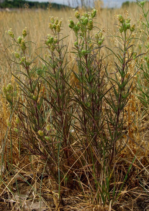
Copyright © : Geonat'ÎdF - Lobelia